WHERE THE INCINERATOR WILL GO AND COMMUNITIES AFFECTED
The incinerator is intended to be built at Loganswell Farm, just outside Newton Mearns, and in clear sight of the M77, the Whitelee Windfarm, Ballageich Hill, and many roads and scenic spots in the area. The map below shows the precise location:
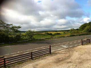
As you can see, Europe's largest primary school (Mearns Primary) is less than 2 miles from the proposed incinerator, and large built up areas are about a mile and a half. In a typical 20 mph wind discharge from the incinerator would be over these houses in less than 5 minutes.The area proposed is a quiet countryside area, designated as green belt by the Council. The following picture shows where the incinerator could be built:
We have obtained information from the Met Office concerning the typical wind direction and speed in the area - see the wind rose diagram below:
Information from the Met Office shows that communities including Stewarton, Barrhead, Newton Mearns, Giffnock, Eaglesham, Waterfoot, Stamperland, Netherlee and beyond are all in the path of prevailing winds.
Information from the Met Office shows that communities including Stewarton, Barrhead, Newton Mearns, Giffnock, Eaglesham, Waterfoot, Stamperland, Netherlee and beyond are all in the path of prevailing winds.
This means that there is a good chance that any particulates and pollutants, such as nanoparticles, furans and dioxins, emerging from the LRV operation will reach these communities on a sustained basis. There is no reliable data on the long-term health effects of exposure like this but the substances in question are well-known as cancer-causing agents.
The size and height of LRV’s development is such that it will be a visible blight on the landscape from Ben More, Ben Lomond, the Campsies, from across Glasgow, the Campsie Braes, East Kilbride and from Lanarkshire: it will significantly damage existing and potential amenity and leisure value in the location.
A leaflet produced by LRV as part of its “public consultation” featured an inaccurate map of Newton Mearns that gave the impression that residential areas are at least half a mile further away from their incinerator site than is actually the case.
LRV have also concentrated on releasing artists impressions of the incinerator complex with oblique and aerial views which seem to deliberately give the impression that the site will completely blend in with the surrounding landscape because of its infamous grass covered roof. This may be true for someone viewing the site from an aeroplane but for the rest of us it will be all too clear that this vast, industrial complex will cover an enormous area equivalent to 27 international rugby pitches and between chimneys and buildings will be 300 feet high (for comparison the Glasgow Science Centre tower is 417 feet high).


